Note: This information was compiled during the 2017 transition to the IDO, and the documents cited in this section may no longer be up to date.
An Integrated Development Ordinance, or IDO, is one ordinance that includes all the land use and zoning regulations that relate to development in Albuquerque.
From the 1970s to 2013, the City adopted a huge number of standalone documents to shape private development and streetscape standards. These included an off-the-shelf Zoning Code adopted in the 1970s, a Development Process Manual of engineering and technical standards, a Subdivision Ordinance, over 60 sector development plans (some 40 of which establish over 400 unique zones in specific areas), several historic overlays, Corridor Plans, and Area Plans.
These standalone documents were hard to find, often conflicting, and many times vague as to whether they were guidance only (policy) or required (regulations). Perhaps more importantly, each of these documents was created at different times, with different intents, and different levels of detail. Despite best intentions, many were not coordinated with pre-existing documents to ensure that they were consistent with each other or effective in implementing the vision adopted in the Comprehensive Plan. In some cases, a particular property may have two or three or four or five layers of regulation trying to guide what can be developed. This led to confusion on the part of property owners, neighbors, and enforcement staff and ultimately undercut the effectiveness of each plan. Resulting development often failed to meet expectations of stakeholders, each of whom may have had a different idea of what was allowed by a single document or across multiple documents.
Additionally, under the old system about half of the city was left out of planning efforts. Even in areas with plans, some plans were updated multiple times and stayed very up-to-date, while other plans were never updated after their adoption as far back as the 1970s. This resulted in undesirable development, negative impacts on the health of the surrounding neighborhoods, and a lack of protections for special places. This inequitable distribution of City resources and planning efforts had outsized negative impacts on low-income areas and communities of color.

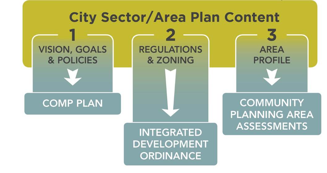
The City tackled this tangle of regulations in coordination with an update to the Comprehensive Plan. The Comprehensive Plan sets the vision and policies to guide how development should look and feel. The IDO sets the rules/regulations about what can develop and what requirements must be followed to help implement the Comprehensive Plan's community vision.
This project was a huge opportunity to clarify what can be required ( regulated) versus what can only be guidance (policy). It has also provided an exciting opportunity to remove conflicts, update ineffective rules and policies, streamline the process for high-quality development that helps us achieve the community vision, and establish an ongoing schedule of community planning and regular updates to the Comp Plan and IDO.
See also:
The IDO was first adopted via Ordinance 17-49, enacted in November 2017, and became effective 6 months from the enactment date on May 17, 2018. The 6-month period allowed time for IDO Trainings for staff, developers, and the public, as well as time to amend errors and omissions.
- Council adoption: November 13, 2017
- Mayor signed: November 16, 2017
- City Clerk published: November 17, 2017 (the enactment date)
- IDO effective date: May 17, 2018
Companion legislation (Resolution 18-29) directed the Planning Department to provide a 1-year process from May 2018 to May 2019 for property owners to opt in to a voluntary follow-up zone conversion process to address existing mismatches in land use and zoning, uses made nonconforming by the IDO, different zoning for properties formerly zoned with Special Use zoning (e.g. SU-1, SU-2, or SU-3), and voluntary downzoning of individual properties.
The IDO is a 21st-century regulatory system that helps implement the City’s adopted vision, encourages new and varied lifestyle options for our residents, and gives our children incentives to stay in Albuquerque when it is time for them to “leave the nest” as young adults.
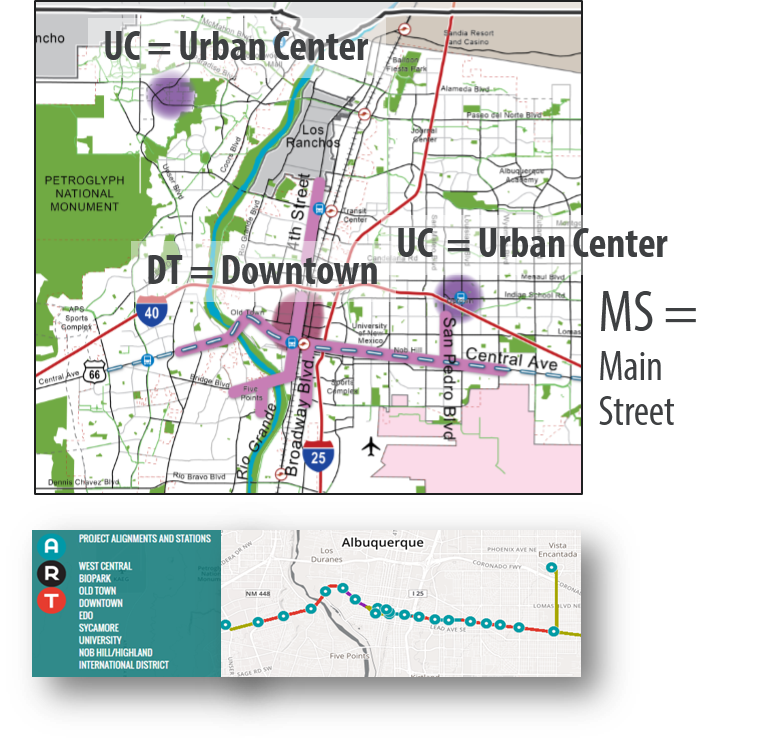
Specifically, the IDO provides regulations tailored for Centers and Corridors from the Comprehensive Plan. In the IDO, there is a table that indicates which sections of the IDO have special provisions for a particular Center or Corridor, including the page number for each map. Generally, taller buildings are allowed in DT-UC-MS-PT areas, and less parking is required. As walkable, urban districts well-served by transit, it makes sense that less parking would be mandated in these areas.
The IDO implements the Comprehensive Plan's policies related to protecting single-family neighborhoods and Open Space through automatic protections built into Major Public Open Space Edges (Subsection 5-2(J)), Edge Buffers (Subsection 5-6(E)), and Neighborhood Edges (Subsection 5-9).
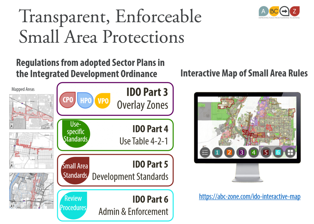
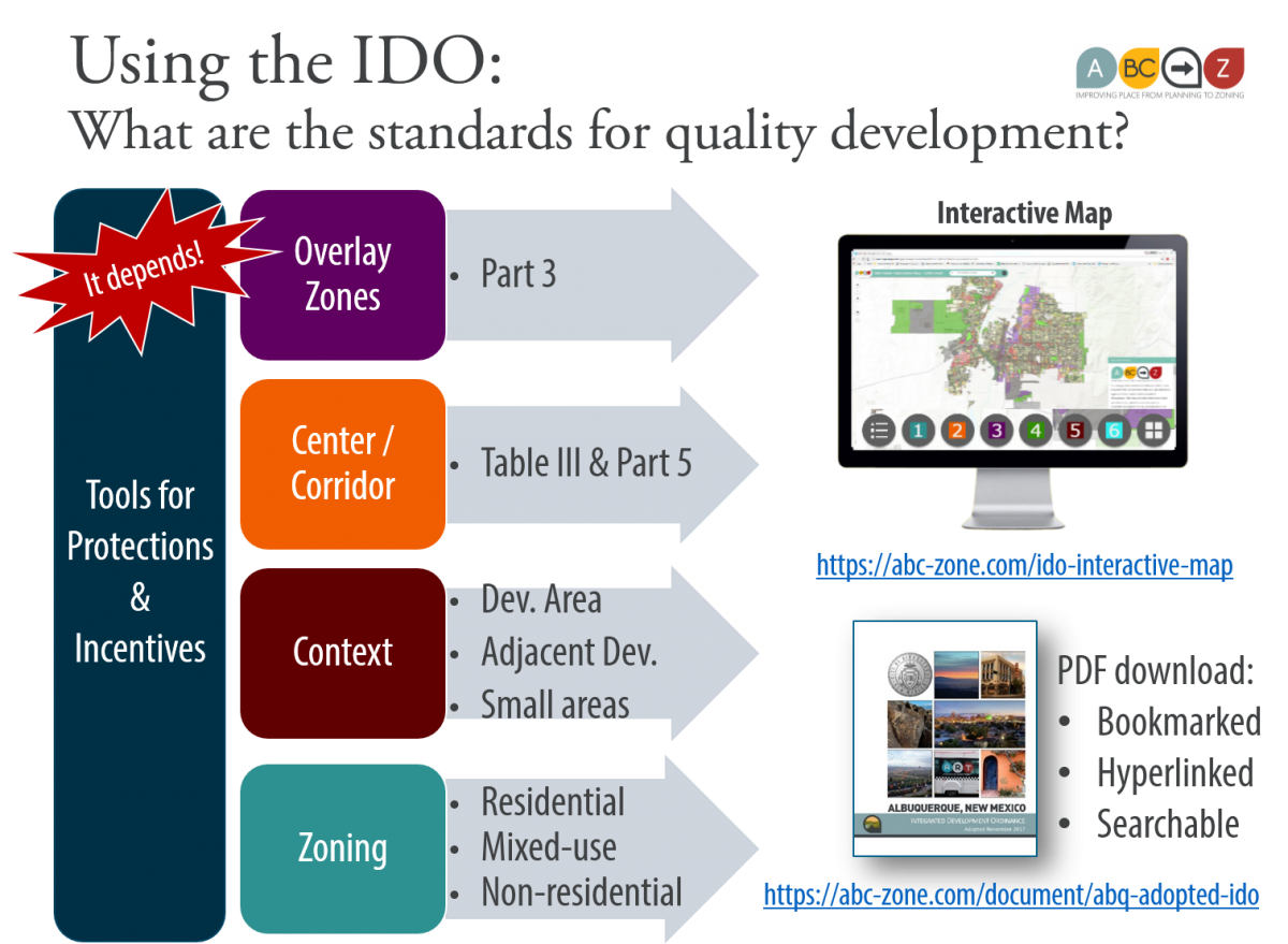
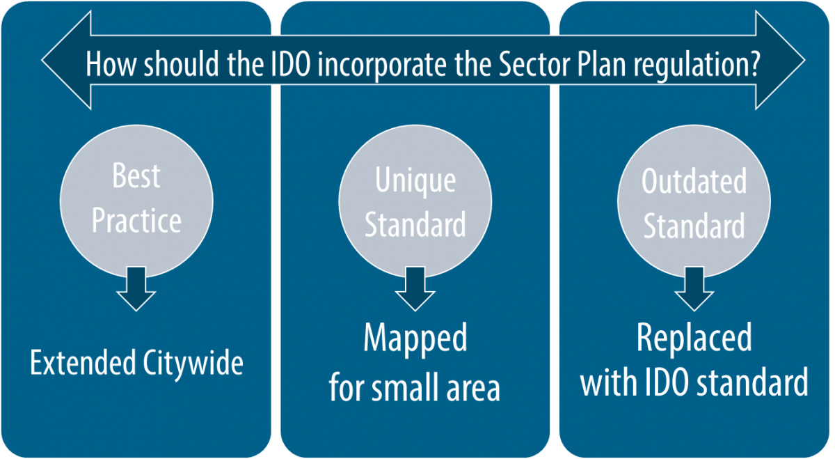
The IDO carries over special rules for small areas as part of an Overlay Zone or a mapped Use Specific Standard, Development Standard, or Review/Approval provision.
In the case of Downtown, the form-based approach to zoning is carried over by converting to the Mixed-use Form-based zone districts (MX-FB). Recent development based on this plan have been mixed-income residential projects, with both market-rate and affordable housing units: the Silver Gardens, Silver Moon, Casita de Colores, Imperial Building, and Silver Lofts.
In general, the IDO builds in a bonus of an automatic extra story (12 feet) of development for Workforce Housing, which is intended as an incentive to encourage more housing options for teachers, fire fighters, and other working-class residents.
The IDO also introduces new housing options, such as Cottage Development, that help residents "age in place" and that can meet increasing market demand for rural living without negatively impacting rural character.
Lastly, by converting 1200+ zones into a set of 20 zones with higher quality standards across the board, the IDO helps streamline development approvals for projects that follow the rules, allowing more development to go straight to building permit with a zoning check along the way, providing predictability of what is allowed and required for staff, neighbors, property owners, and developers.
Given all of the above, the IDO is intended to result in more development of a higher quality where the Comprehensive Plan determines that it is appropriate.
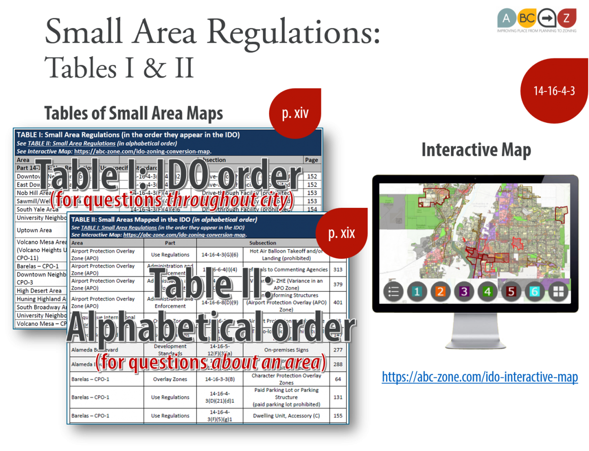
Absolutely not! The IDO includes many regulations tailored to protect the character and address the important issues of many places within adopted sector development plans and historic areas. There are over 40 small areas with tailored protections in the IDO (encompassing over 180 individual protections). These protections appear in every content section of the IDO. They are mapped on the Interactive IDO Zoning Map, which has buttons with numbers that track with the content sections of the IDO, and they are indexed in Table I (in order of the IDO) and Table II (in alphabetical order of the small areas) following the table of contents in the IDO.
In addition, the uses allowed on each property depend not only on the property's zone district but also on the context of that property - whether it's adjacent to a low-density residential zone district (R-A, R-1, R-MC, or R-T) or Major Public Open Space. If so, certain uses are more highly regulated with use-specific standards, or made conditional so that there's a process to ensure that the new use will be compatible with existing development, or prohibited outright if the use is incompatible with low-density residential or with Major Public Open Space.
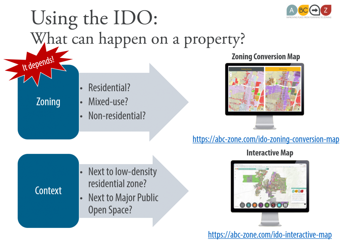
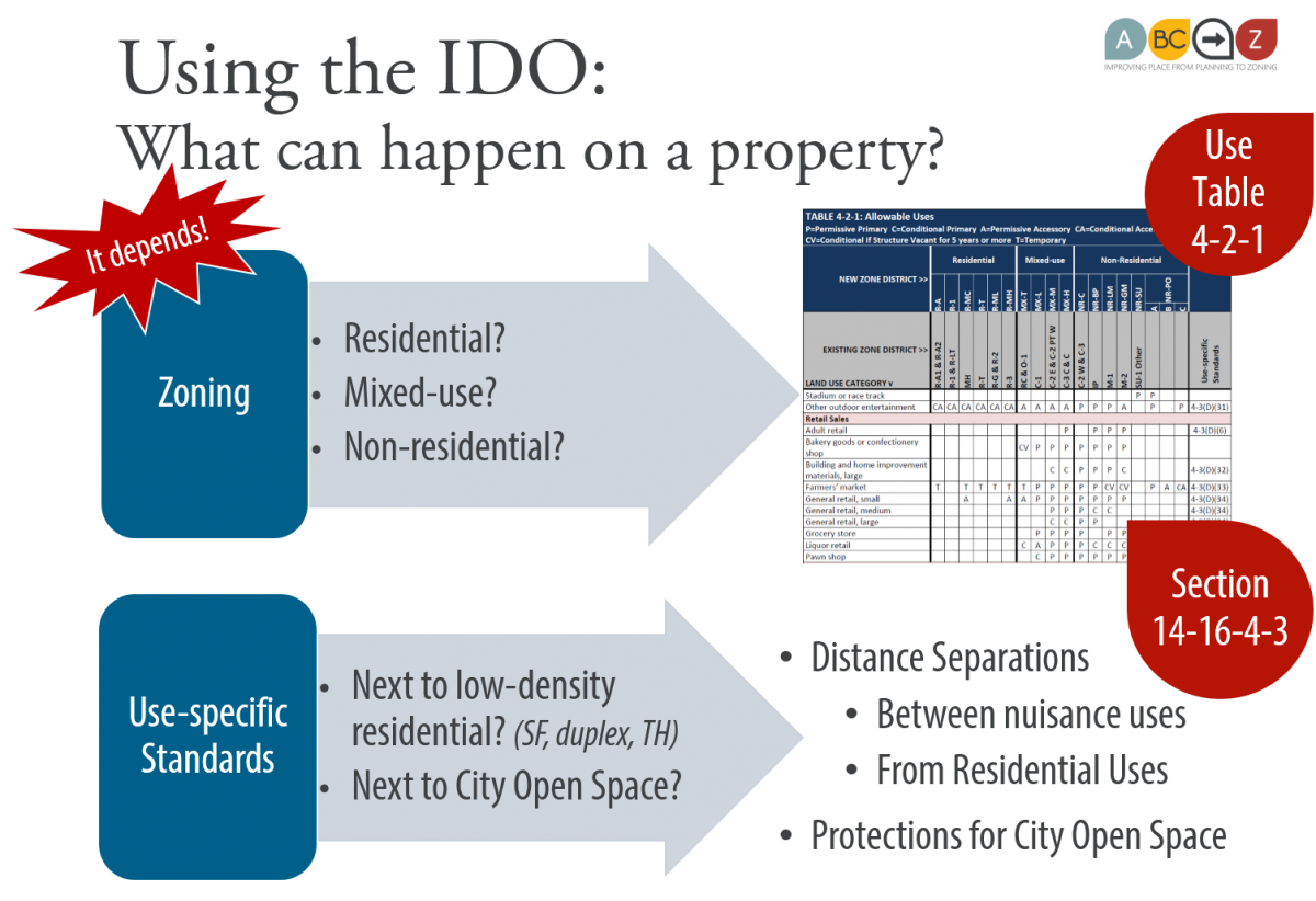
The development standards that apply to each property also depend not only on the property's zone district but also on whether the property is in an Overlay Zone (development standards unique to a small area carried over from the adopted Sector Development Plans), a Center or Corridor as defined by the Comprehensive Plan, an Area of Change or Consistency as defined by the Comprehensive Plan, next to a low-density residential zone, or next to Major Public Open Space. The standards for each property depend on all these factors, which is hardly one-size-fits-all!
Lastly, the review and approval process for an individual project depends not only on the property's zone district (PD, PC, NR-BP, and NR-SU go to the EPC for site plans, for example) but also the size of the project. Smaller projects can be reviewed and decided administratively by staff. Larger projects are reviewed and decided by the Development Review Board. Projects greater than 5 acres next to Major Public Open Space have to go the EPC.
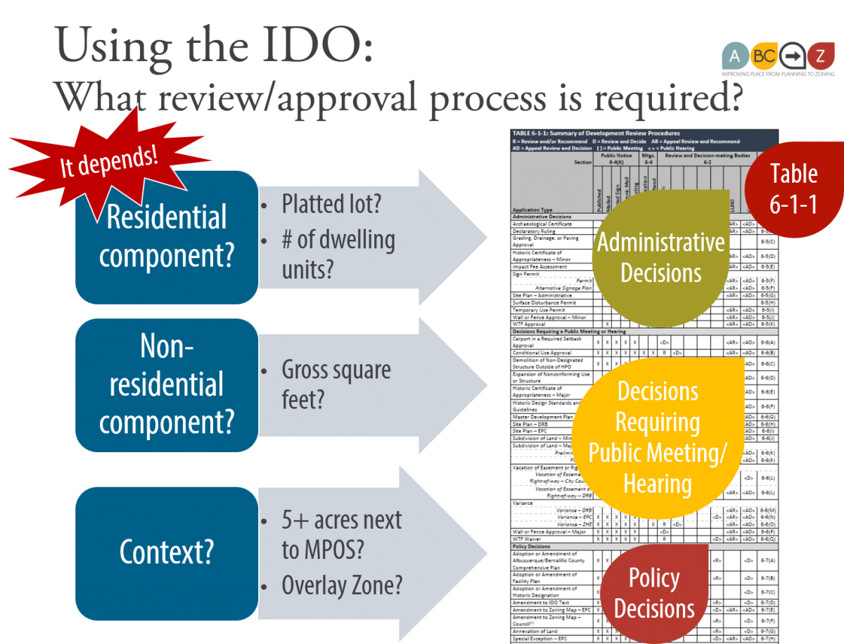
The IDO takes a citywide approach to establishing what factors should influence uses, development standards, and review/approval processes. In each case, important factors address what is appropriate on each property based on the property's context and the project's size.
See also:
Absolutely not!
Our previous system relied heavily on Neighborhood Associations negotiating for quality standards and neighborhood protections through Special Use zones at the Environmental Planning Commission -- at least for the half of the City with SU-1 or SU-2 zoning. This system was highly inequitable, relying on the time and attention of those neighborhoods that could be involved full-time in development decisions.
The other half of the City was regulated under the 1970s zoning code with very few protections, quality standards, or notice requirements to Neighborhood Associations.
The IDO rebalances the system so that the quality standards and neighborhood protections are written into the IDO as objective requirements that are not negotiated on a case-by-case basis. These increased standards allow more development review by staff and less review before discretionary decision-makers.
The IDO includes more notice to neighborhood associations than the previous zoning ordinance. The IDO includes more protections citywide through Neighborhood Edges, varieties of R-1, building design standards, and development standards near Major Public Open Space.
The new IDO commits the City to an ongoing 5-year cycle of Community Planning Area Assessments that provide opportunities for long-range planning with all neighborhoods and stakeholders, not just those with Sector Development Plans, some of which were never updated and over half of which were more than 10 years old. The IDO is updated every two years to increase transparency and provide ongoing opportunities for improving our land use regulations.
There is no question that the IDO has been an overhaul of our previous land use, planning, and zoning system, not for nefarious purposes, but to follow best practices for a more transparent, equitable, and efficient land use and zoning framework with better protections for all neighborhoods and better planning citywide.
See also:
- Why did the IDO change review and approval processes?
- Is the City doing away with Neighborhood Associations?
- How will the City improve public engagement with the community?
- What is a Community Planning Area Assessment?
- When did the Community Planning Area Assessments begin
- How does the IDO handle public notice of development projects?
- Sector Plan provisions extended citywide through the IDO
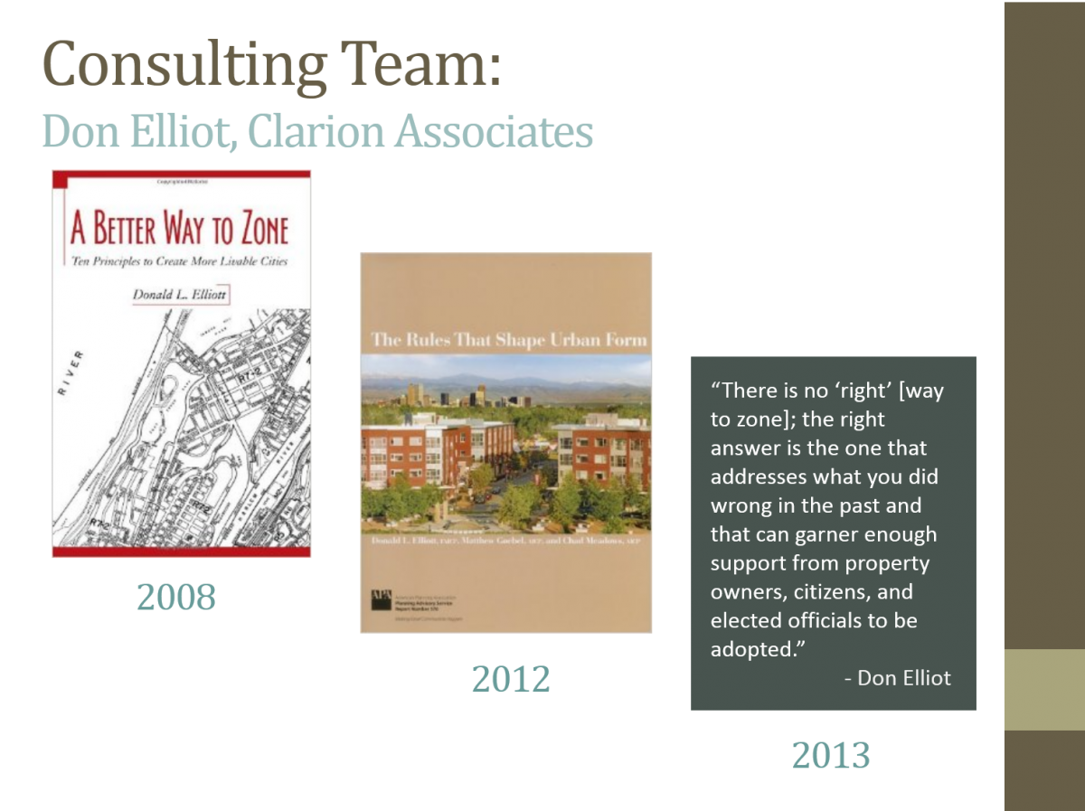
Clarion Associates, a Denver-based firm specializing in writing zoning codes for local municipalities, was the lead consultant for the IDO effort. The consultant has worked in over 130 cities and tackled some incredibly challenging projects, such as a new code for Philadelphia, and projects in Western auto-oriented cities similar to Albuquerque, such as Tucson. Their team was chosen for their pragmatic approach to zoning, with experience working with the full range of approaches and tools that can best address a particular issue.
The IDO effort involved five steps, with meetings at each stage with stakeholders from February 2015 to December 2016:
- Assessment of existing regulations and recommendations,
- New zoning districts and uses allowed in each,
- Design standards that determine the required quality of development,
- The processes and criteria for review and approval of development projects, and
- Mapping of new zone districts.
Long-range staff from the Planning Department and Council Services planning staff made up the project team for the ABC-Z project, including both the ABC Comprehensive Plan update and the IDO.
As part of the IDO adoption, ABC-Z replaced over 1,200 individual zones and overlays under the previous Zoning Code to a set of fewer than 25 zones in the IDO. The project team matched permissive uses in the pre-existing zoning with the closest matching set of permissive uses in the IDO zones. This is referred to as the Phase 1 Zoning Conversion.
See how pre-existing zones converted into IDO zones on this map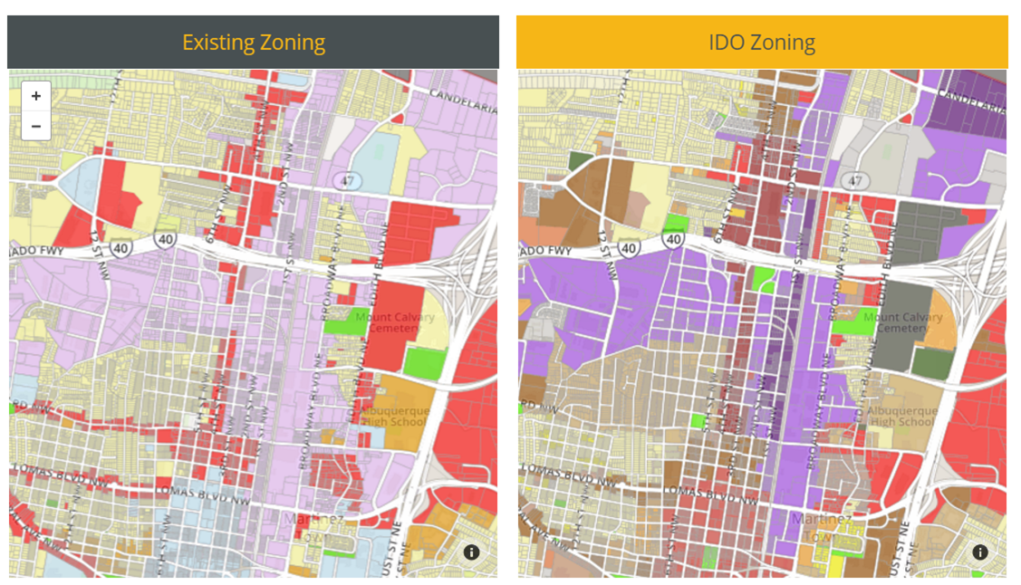
There were thousands of properties with land uses that did not match the zoning they had before they were converted, and the Phase I conversion did not correct this mismatch. The year after the IDO became effective, the City offered a free opt-in zoning conversion process for property owners to address this and several other issues not resolved by the initial zoning conversion. Read more about that process here:
Property owners can always request a zone change through the standard process.
Existing development that was legal before the IDO remains legal after the IDO adoption, in terms of uses and design.
Base Zones (from the City Zoning Code)
- There were approximately 30 base zones (i.e. R-1, R-T, C-1, C-2, M-1 etc.) in the City's previous Zoning Code.
SU-2 and SU-3 Zones (from Sector Development Plans)
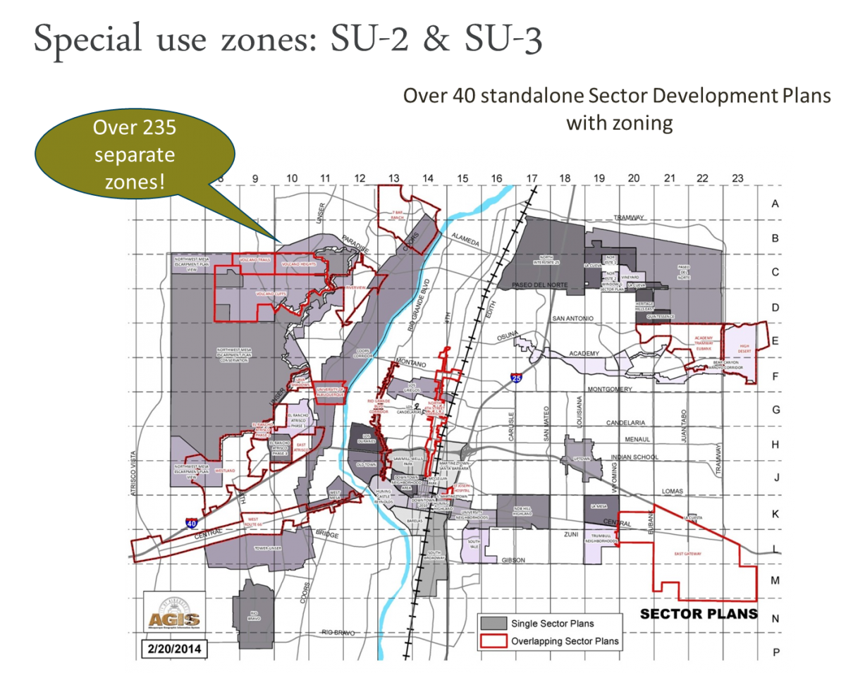
- A table of conversions for each of the 400+ unique SU-2 and SU-3 zones throughout the City is available here.
SU-1 Zones (from adopted Site Plans for individual parcels)
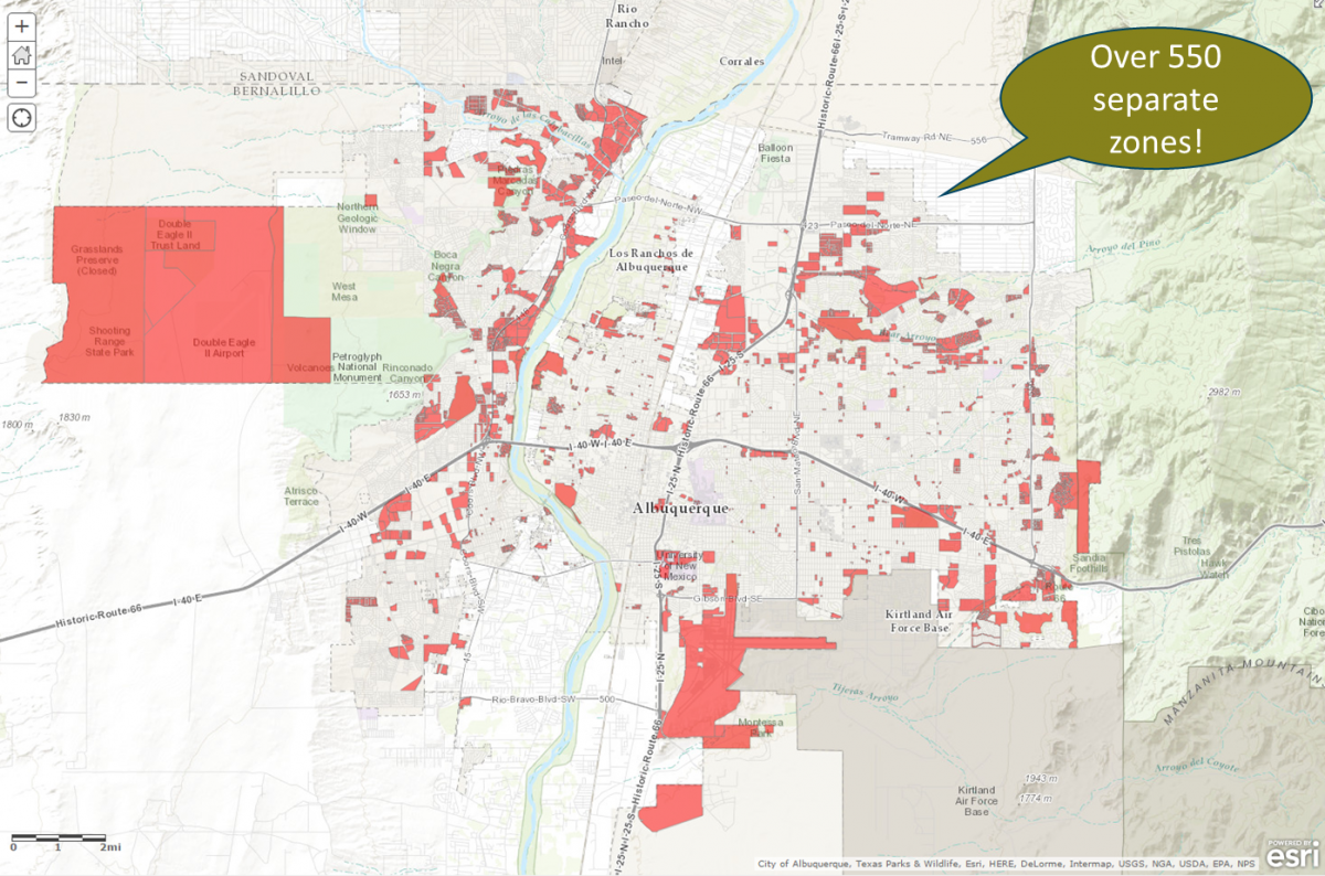
- A table of each of the City's 750+ adopted SU-1 categories of site plans throughout the City is available here.
- These categories include zoning for about 2,000 sites/premises, which include over 23,000 lots and account for over 28,500 acres or approximately 25% of the city's acreage.
- All SU-1 approved site plans remain in place since the adoption of the IDO. If a property owner wants to change their site plan, they can do so under the new IDO.
-
See also:
- IDO Training - Zones & Uses
The IDO converted existing commercial zoning (C-2 and C-3) differently west and east of the Rio Grande for three very important reasons:
- Improving the balance of jobs and housing on the West Side.
- Addressing traffic congestion on river crossings and the surface roads that lead to them.
- Locating new housing options closer to already established employment centers.
Currently, there are 20 percent more jobs than households in Albuquerque, which is a good situation for our economy and our residents. West of the Rio Grande, however, there is only one job for every two households, meaning that most west-side residents are commuting across the river every day to work. When you add in the residents of Rio Rancho, Bernalillo, and other nearby communities that commute to and work on the east side of Albuquerque, the traffic congestion on river crossings and the roads that lead to them becomes a larger, regional issue. This not only affects the quality of life for west side residents that can spend up to two hours a day commuting, but also affects the quality of life for east side neighborhoods that commuters pass through every day on their way to and from work.
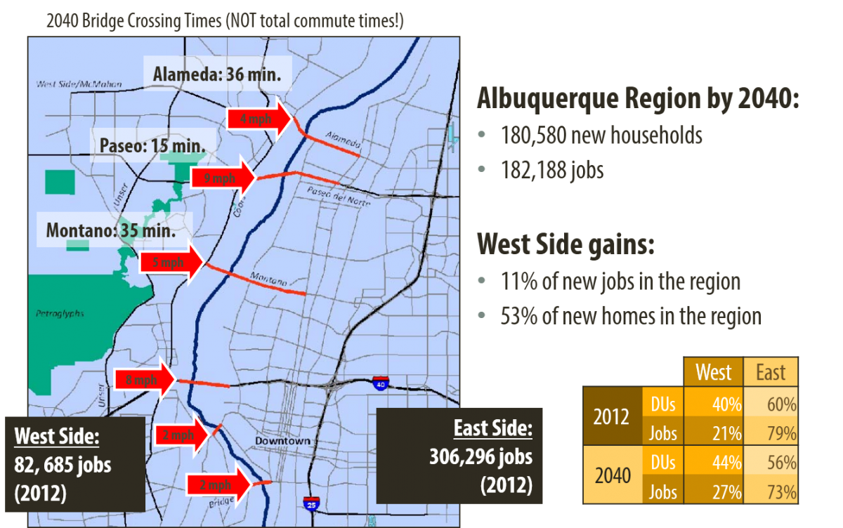
Today, over 80% of all employment in the metro area is located on the East Side of the Rio Grande, most notably along the I-25 corridor from Kirtland Air Force Base, to Downtown, the UNM and CNM campuses, Presbyterian, Lovelace, and UNM Hospitals, the mid- and north-I-25 industrial areas, to Journal Center and beyond. This is evident with the traffic congestion leading to and over our limited river crossings during rush hour in the morning (east bound) and rush hour in the evening (west bound).
The Mid-Region Council of Governments (MRCOG), the regional transportation planning authority for the metro area, predicts that employment on the West Side is expected to grow by over 20,000 jobs by 2040, but this represents only 11 percent of all the job growth expected in Albuquerque. At the same time, the West Side is expected to grow by over 25,000 households. Unless we can help development patterns change, the imbalance of jobs to housing will continue to increase, resulting in even more traffic congestion on river crossings.
Exacerbating the situation over the past two decades have been the piecemeal conversions of commercially zoned and business park zoned land with employment potential on the west side to residential zoning. This has resulted in single-family subdivisions and apartments built in locations with poor access to goods, services, and employment opportunities.
Here are the different conversion rules for the Community Commercial (C-2) zone:
- East Side: MX-M (mixed-use medium intensity)
- West Side: NR-C (non-residential commercial), except for the following circumstances:
Here are the different conversion rules for the Heavy Commercial (C-3) zone:
- East Side: MX-H in Centers/Corridors (Premium Transit, Main Street, Major Transit, Urban Center, and Activity Center), otherwise NR-C
- West Side: NR-C except for Premium Transit Areas, where it converts to MX-H
MX zones allow a mix of residential and non-residential uses on the same site or in the same building. Mixed-use zoning on the East Side encourages residences close to existing job centers, and more jobs to locate near housing. Mixed-use development is the most efficient pattern for growth and for the provision of services and infrastructure. The IDO decreases parking requirements along Transit Corridors because residents are more likely to own fewer or no vehicles and ride transit, walk, or bicycle to commute to work or go shopping since services are within walking distance of their homes.
The NR-C zone does not allow residential uses. Converting to mixed-use zoning on the West Side would almost certainly result in more apartments, given today’s market, which would worsen the jobs/house balance. The conversion to NR-C on the West Side ensures that land will be available for jobs and services, which should also help lessen traffic congestion at peak commuting hours over time.
Existing residential neighborhoods throughout the City will be protected from new, more intense development by Neighborhood Edge provisions, which automatically bring building heights down within 100 feet of low-density residential zones, require more landscape buffers, and limit circulation on the abutting property line.
The IDO, like the Comprehensive Plan, is not geared to benefit one area over another, nor is it intended to provide equality between the East and West sides. Rather, the IDO is intended to provide equity amongst varied communities, given what each area needs and can benefit from, to help keep Albuquerque a great place to live, work, play, and raise a family.
See also:
Yes. The City is statutorily empowered to change zoning laws within the City. Additionally, the City has the responsibility to make sure that zoning laws are updated on a regular basis to ensure the health, safety, and general welfare of its residents.
The IDO was adopted through a legislative process that affects all property in the City. The City is required to provide notice to Neighborhood Associations registered with the Office of Neighborhood Development and to place a legal ad in the local newspaper, both of which were done when the IDO was submitted for review/approval in December 2016.
Under the IDO, existing zoning was converted to a base zone with a set of uses that most closely matched permissive uses under the existing zone, and all legal development has remained legal under the IDO. Existing development that no longer meets the new rules of the IDO is called "nonconforming." Nonconforming development is still considered legal. The new IDO zone district rules "kick in" when a property owner chooses to develop, redevelop, or expand facilities on their properties.
See also:
The term “downzoning” generally refers to a zoning change that narrows the list of allowable uses or lowers the height or size of a building that can be built on specific properties, as opposed to a change that applies more generally through more comprehensive city-wide amendments like ABC-Z. While it was not the intent of the ABC-Z project to downzone property, whether a downzoning occurs can only be determined on a case-by-case basis.
Zoning changes only require compensation to the property owner in the event of a “taking” and only if the zoning change denies all reasonable economic use of the entire property. All parts of the property must be considered together in determining whether there is a reasonable economic use of the property left to the owner. Generally, no property owner has an inherent legal right to the “highest and best use of property,” (a term generally used in property appraisal, not zoning law) or to the zoning in place at the time the property was purchased. ABC-Z zoning conversions did not result in takings, since the zoning was converted to IDO zones that allowed reasonable use rights and land use patterns.
The City received over 1,500 forms from property owners opting into the voluntary zoning conversion process, thanks to many neighborhood associations who helped go door-to-door.
City Council has adopted zoning conversions for all three batches.
- Batch 1: Effective on September 8, 2019. ~140 properties
- Batch 2: Effective on December 18, 2019. ~1350 properties
- Batch 3: Effective on February 17, 2020. ~ 265 properties
Purpose
In May 2018, City Council adopted Resolution 18-29 directing the Planning Department to create a process for property owners to request a zoning conversion (at no cost to the property owner) one year from the IDO's effective date of May 17, 2018.
From May 2018 to May 2019, the City accepted forms from property owners with eligible properties, described in more detail below.
City Review/Decision Process
The City submitted three batches of recommendations for zoning conversion rules for eligible properties for which property owners submitted a complete form by the May 17 deadline. Each property was given a Form ID number that matches with the property owner form, numbered in the order they were received and processed by staff.
- Batch 1: Submitted in November 2018 / Effective September 2019
- Batch 2: Submitted in May 2019 / Approved November 2019 / Effective December 2019
- Batch 3: Submitted in August 2019 / Effective February 2020
Background
When the City adopted a new Integrated Development Ordinance (IDO) and zoning map after 40 years under the old system of Zoning Code + Sector Development Plans, we converted over 1,200 individual zones to a set of about 20, matching permissive uses in the old zones to the closest set of uses in one of the new IDO zones.
- As a 300-year old city that largely developed before zoning was ever created, Albuquerque has many properties with existing land uses that don't match zoning. The initial IDO zoning conversion didn't address this land use-zoning mismatch.
- There are also many cases where single-family homes were built in zone districts that also allowed apartments, and those homeowners indicated that they would rather have a zone that only allows single-family homes. The initial zoning conversion did not address this desire for a downzone.
- On other properties, for a variety of historical reasons, there are 2 zone lines. The initial zoning conversion did not fix these floating zone lines.
- Many of the City's old zones controlled uses and development standards for each property as a unique site plan. Many undeveloped properties never had such a plan to establish their uses, so the initial zoning conversion used the title of the zone to match to the closest set of uses in the new set of IDO zones, which may not reflect the intentions of the property owner for future development.
- As a 40-year overhaul of our Zoning Code, the Integrated Development Ordinance made many changes to uses and zoning standards. The initial zoning conversion did not address conflicts between existing uses and new standards.
Eligible Properties
City Council Resolution 18-29 directed the Planning Department to create a process for property owners to request a zoning conversion (at no cost to the property owner) for one of the following reasons:
- Nonconforming Use: address existing uses made nonconforming by the IDO or mismatches of land use and zoning that pre-existed the IDO.
- FAQ: How do I find out whether I have a nonconforming use?
- Example 1: You have a single-family detached house on a property zoned MX-L, MX-M, MX-H, NR-C, NR-LM, or NR-GM.
- Example 2: You are operating an industrial use that was allowed in C-3 that is not allowed under the IDO conversion to MX-H.
- Voluntary Downzone: downzone properties with low-density residential development (houses, duplexes, or townhomes) in an Areas of Consistency by property owner request (for example, R-T to R-1).
- Example: You have R-T zoning but would like to have R-1 because you have a single-family house on your lot, and you're surrounded by other lots with single-family homes.
- Floating Zone Line: request adjustments to fix floating zone lines that do not match lot lines.
- FAQ: What is a floating zone line and how do I find out whether I have a floating zone line on my property?
- Example: you have two zones on a lot because your platting doesn't match the zoning boundaries.
- Prior Special Use or R-D Zoning: request a more appropriate zone for undeveloped properties formerly zoned with a Special Use zone (SU-1, SU-2, or SU-3) or R-D.
- Example 1: You have an undeveloped property that was zoned R-D but is now PD that was platted for a single-family home, and you want to convert to R-1.
- Example 2: You have an undeveloped property that was zoned SU-1 for C-1 + self-storage that was converted to MX-L, and you would like to request that it convert to MX-M, which allows self-storage permissively.
- Size Thresholds: request a more appropriate zone for properties with PD or NR-BP zoning that do not comply with the minimum and maximum lot sizes set by those zone districts.
- Example: You have PD zoning but your property is <2 acres or ≥ 20 acres.
- Example: You have NR-BP zoning but your property is <20 acres and is not part of an existing Master Development Plan.
In December 2018 and March 2019, staff identified eligible properties and sent mailed notice to the property owners on file with the Bernalillo County Assessor.
Zoning Map Amendments
Please note that all property owners also have the option of requesting a zone change through the normal zoning map amendment process. There is a fee, and the request will be processed as a quasi-judicial procedure. From submittal deadline to the first hearing is 6 weeks. The zoning map amendment will need to be reviewed by the Environmental Planning Commission in all cases and by the City Council for properties over 10 acres in size.
Frequently Asked Questions
- How does zoning affect property taxes?
- What was the process to get a follow up zone conversion?
- What is the process for getting a zone change for my property?
Resources
- Map of Properties Likely to Be Eligible for the Follow-up Voluntary Zoning Conversion Process
- Phase 1 Zoning Conversion Map
- Phase 2 Zoning Conversion Map
Purpose
In May 2018, City Council adopted Resolution 18-29 directing the Planning Department to create a process for property owners to request a zoning conversion (at no cost to the property owner) for one year from the IDO's effective date of May 17, 2018.
Batch 1 - Submitted in November 2018 - Effective September 8, 2019
Zoning conversions for properties submitted as batch 1 in November 2018 were approved by City Council via Ordinance 19-65 in August 2019. The Ordinance became effective on September 8, 2019, and the Official Zoning Map was updated.
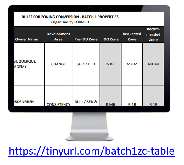
A table of properties in Batch 1 is available for online review or download as a PDF here.
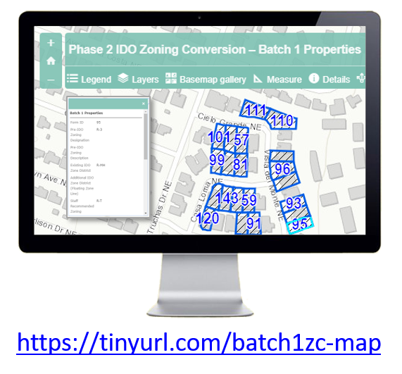
A map of Phase 2 zoning conversions is available here.
Clicking on one of these properties will pop up a box with key information, including:
- Form ID (which tracks with the form submitted by the property owner)
- Pre-IDO and current IDO zoning
- Which criteria make the property eligible for this process
- T zoning conversion for the property approved by City Council
You can also see properties submitted in Batch 2 or Batch 3 by clicking "Layers" at the top of the map and clicking on the box in front of the layer of information you want to see.
City's Review and Decision Process
Step 1 of 3: Environmental Planning Commission (EPC) Review & Recommendation
Planning staff submitted the first batch of properties to the City's review/decision process in November 2018. On January 10, 2019, the Environmental Planning Commission (EPC) reviewed and voted to send a recommendation of approval of the proposed zoning conversion rules for the 122 properties in Batch 1 to City Council.
- The Staff report and Notice of Decision are available here. (See Project#2018-001843/ Case#RZ-2018-00057)
- The presentation by staff to the EPC at the study session on 12/13/18 is available here.
- The presentation by staff to the EPC on 1/10/19 is available for review here.
Step 2 of 3: City Council's Land Use, Planning, & Zoning (LUPZ) Committee
On June 12, the City Council's Land Use, Planning, and Zoning (LUPZ) Committee voted to send the Batch 1 Zoning Conversions to the full City Council for final decision with no recommendation. LUPZ directed Council and Planning staff to provide additional documentation for properties only eligible for a zoning conversion via the nonconforming or floating zone line criteria. This documentation was submitted to the City Council prior to the August 5 public hearing at the full City Council in Step 3 of 3.
Step 3 of 3: City Council
City Council adopted zoning conversion rules for Batch 1 properties on August 5, 2019 via Ordinance 19-65. The Ordinance became effective on September 8, 2019, and the Official Zoning Map was updated.
- Form ID numbers 14, 128, 129, and 130 were withdrawn by the property owners.
- Form ID number 4 was removed by City Council as ineligible, since the existing use on the property was not found to be nonconforming.
The following amendments were also adopted:
Purpose
In May 2018, City Council adopted Resolution 18-29 directing the Planning Department to create a process for property owners to request a zoning conversion (at no cost to the property owner) for one year from the IDO's effective date of May 17, 2018.
Submittal - May 2019
On May 30, 2019, Planning staff submitted over 1,200 properties in Batch 2 to the City's review/decision process for zoning conversions.
Properties in Batch 2 are shown on this online interactive map.
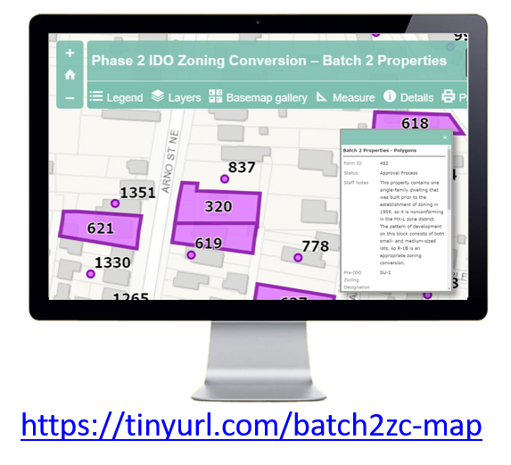
Clicking on one of these properties will pop up a box with key information, including:
- Form ID (which tracks with the form submitted by the property owner)
- Pre-IDO and current IDO zoning
- Which criteria make the property eligible for this process
- Zoning conversion for the property recommended by staff
You can also see properties submitted in Batch 1 or Batch 3 by clicking "Layers" at the top of the map and clicking on the box in front of the layer of information you want to see.
City's Review and Decision Process
Step 1 of 3: Environmental Planning Commission (EPC) Review & Recommendation
- EPC study session June 13, 2019: Review presentation here.
- EPC hearing July 11, 2019: EPC voted to send a recommendation of approval of the proposed zoning conversion rules for the 1,226 properties in Batch 2 to City Council.
Step 2 of 3: City Council's Land Use, Planning, & Zoning (LUPZ) Committee
Batch 2 legislation is proposed as Ordinance 19-79. On October 16, 2019, the City Council's Land Use, Planning, and Zoning (LUPZ) Committee voted to recommend "Do pass" to the full City Council after approving 5 amendments.
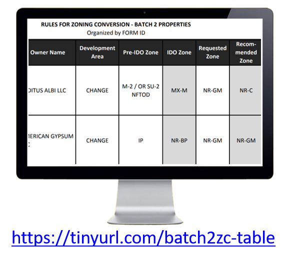
- Amendment A - Revised zoning conversion for Form ID#403 from NR-C to NR-LM
- Amendment B - Revised zoning conversion for Form ID#1042 from R-T to R-ML
- Amendment C - Revised zoning conversion from MX-T to R-1A:
- Form ID # 205, 1715 7th St NW
- Form ID # 213, 2706 2nd St NW
- Form ID# 483, 1416 Franciscan NE
- Form ID# 617, 1410 Franciscan NE
- Form ID# 1040, 1313 1st St NW
- Amendment D - Revised zoning conversion from MX-T to R-ML:
- Form ID # 324, 2705 1st Street NW
- Form ID # 650, 1223 Broadway NE
- Form ID# 1115, 631 McKnight NW
- Amendment E - Removed Form ID #1435 and #544
Step 3 of 3: City Council
Zoning Conversions for Batch 2 properties became effective on December 18, 2019. The Official Zoning Map will be updated as soon as possible.
Batch 2 properties were approved by the City Council on November 18 via Ordinance 19-79. Council also approved Amendments A, B, C, and D.
Council removed the following properties from Batch 2 by request of the property owner via Amendment A:
- Form ID 697:
- Lots 3A, 4A, 5A, 6A, 7A Blk 6 Paris Addn
- Form ID 1421
- Form ID 1422
Council added Form ID 1094 via Amendment B to convert to MX-L as eligible via a nonconforming use.
Council removed the following properties from Batch 2 via Amendment C for insufficient information that rendered their applications incomplete:
- Form ID 455
- Form ID 1131
Council removed the following properties from Batch 2 via Amendment D as ineligible for the process, since the existing use was deemed not nonconforming:
- Form ID 1089
- Form ID 1343
Purpose
In May 2018, City Council adopted Resolution 18-29 directing the Planning Department to create a process for property owners to request a zoning conversion (at no cost to the property owner) for one year from the IDO's effective date of May 17, 2018.
Batch 3 - Submitted for Review/Decision in August 2019/ Effective February 2020
City staff found 7 forms from property owners that had been submitted prior to the April 2019 deadline that were inadvertently misplaced and therefore not submitted with Batch 2 in May. These properties were submitted as Batch 3 in August 2019.
Additionally, 29 properties submitted prior to the April 2019 deadline that staff initially deemed ineligible for the zoning conversion process were included to give decision-makers the opportunity to consider the appropriateness of the requested zoning conversion given the surrounding zoning.
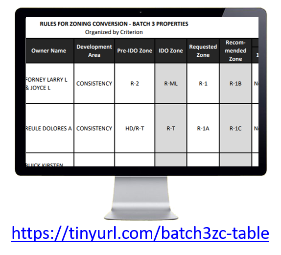
A map of properties in Batch 3 is available here.
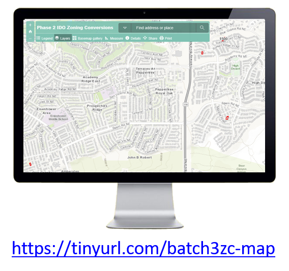
Clicking on one of these properties will pop up a box with key information, including:
- Form ID (which tracks with the form submitted by the property owner)
- Pre-IDO and current IDO zoning
- Which criteria make the property eligible for this process
- Zoning conversion for the property recommended by staff
You can also see properties submitted in Batch 1 or Batch 2 by clicking "Layers" at the top of the map and clicking on the box in front of the layer of information you want to see.
City's Review and Decision Process
Step 1 of 3: Environmental Planning Commission (EPC) Review & Recommendation - Complete
Batch 3 was heard by the Environmental Planning Commission on October 10, 2019. EPC voted to recommend approval of Batch 3 properties based on findings that supported the request for 7 properties on the East Side requesting a voluntary downzone and findings that did not support the request for 29 properties on the West Side requesting a zone conversion based on the Special Use criterion from MX-L to MX-T, which would allow single-family development.
Step 2 of 3: City Council's Land Use, Planning, and Zoning (LUPZ) Committee - Complete
Batch 3 was reviewed by the City Council's Land Use, Planning, and Zoning (LUPZ) Committee on January 15, 2020 and sent to the full City Council with no recommendation.
Step 3 of 3: City Council - Complete
Zoning conversions for all Batch 3 properties were adopted by City Council on February 3, 2020 via Ordinance 19-89. The legislation became effective on February 17, 2020. The Official Zoning Map will be updated as soon as possible.
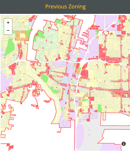
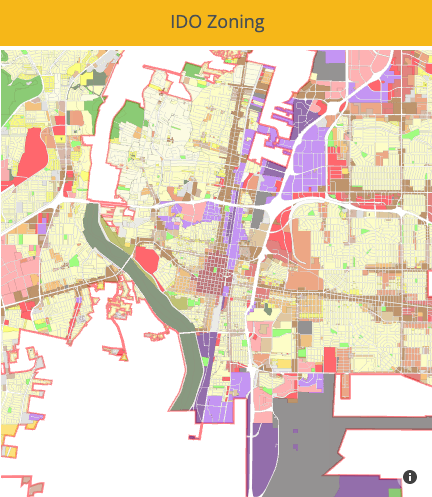
The City of Albuquerque adopted a new set of zone districts in the Integrated Development Ordinance (IDO), effective May 17, 2018.
The maps below compare previous zoning to IDO zoning, which was converted based on the closest matching set of permissive uses.
• The Official Zoning Map is available using the Advanced Map Viewer and the IDO Zoning Map.
• To review requested zoning conversions in Phase 2, visit this webpage.

To learn more about uses allowed under the PREVIOUS zoning:
- Straight zones (R-1, C-2, M-1, etc.): Consult the Comprehensive Zoning Code
- SU-1 (site-plan controlled parcels): Visit the file room in the Planning Department on the 3rd floor, Plaza del Sol, 600 2nd Street, M-F 8:30 am – 12 pm and 1-4:30 pm.
- SU-2 (sector development plan zones): Consult the relevant sector plan available online here.
To learn about uses allowed under the IDO:
- Integrated Development Ordinance: See Allowable Use Table 4-2-1 and Use-specific Standards in Subsection 4-3
- Frequently Asked Questions about the IDO:
- Zoning Conversion Rules & Information
- Base zone (R-1, C-2, M-1, etc.) conversion table
- SU-1 (site plan-controlled parcels) and R-D zones conversion table
- Note: Approved site plans keep their uses and zoning standards. For uses approved on each site, please consult the adopted site plan. If a new site plan is needed, the IDO zoning and review/approval processes apply.
- SU-2 and SU-3 (Sector Development Plan zones) conversion table
- IDO Zoning Interactive Map of Overlay Zones and small area regulations
The adopting legislation for the Integrated Development Ordinance (Ordinance (O-17-49) and companion legislation amending related adopted Resolutions Resolution (R-17-213), as well as the IDO Section 5-3 on the City's Planning system, all work together to clarify that the City's Ranked System of Plans are policy documents adopted to provide guidance on facilities, investments, and management to implementing City departments. 
Additional neighborhood protections established by the IDO can be found here.
The IDO extended the following Sector Plan protections citywide.
No. Absolutely not. All existing, legal development was allowed to remain after the IDO was adopted. The IDO cannot and did not eliminate existing single-family dwellings.
The IDO replaced the City’s 40-year-old Zoning Code and adopted Sector Development Plans and converted prior zoning to an equivalent set of zones with roughly the same set of permissive uses. This zoning conversion process was done in a way that generally preserved prior zoning entitlements.
As an added precaution, the City provided a free zoning conversion process that property owners could opt into for a year after the IDO becoming effective. This follow-up action provided the opportunity to address those instances where existing zoning does not match the existing land use or where the existing land use is no longer allowed in the converted IDO zone.
See also:
The Large Retail Facility requirements were part of the Shopping Center Regulations in the previous Zoning Code (§14-16-3-2).
The Building Design Standards for mixed-use and non-residential development in IDO Section 5-11 were largely drawn from the zoning code’s General Building and Site Design Regulations for Non-Residential Use (§14-16-3-18). These building articulation, design, outdoor gathering space, and parking lot design requirements are largely the same as the ones required for big box developments under the previous Zoning Code.
Requirements related to roadway access, parking lot design, and building articulation were also carried forward as use-specific standards for General Retail in Subsection 4-3(D)(37)(b) to carry over portions of the Large Retail Facilities regulations, including:
- Roadway access requirements for large retail facilities,
- Site division requirements that are intended to allow sites to evolve into more urban, mixed-use development over time, and
- Building design and sign design requirements to enhance the design and massing of these large format buildings.
Finally, the definition for “Large Retail Facility” was carried forward into the IDO Definitions Section 7-1.
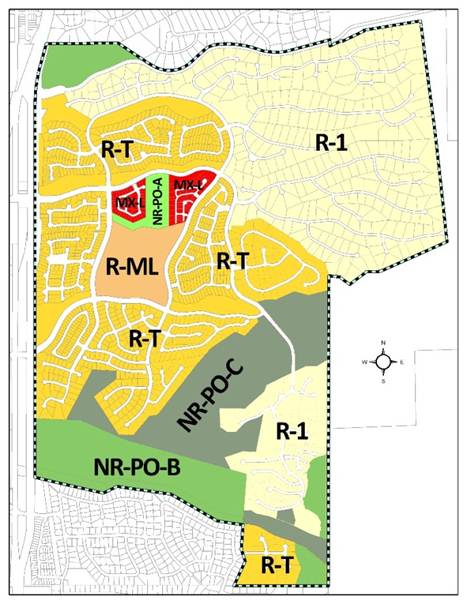
Pre-IDO Zoning in the High Desert Sector Development Plan
Zoning Conversion Map as of December 2016
Zoning Conversion Map as of August 2017
Based on the University of New Mexico’s Bureau of Business and Economic Research review of cases submitted between 2014-2016, the EPC saw approximately 16% of the development applications that the Planning Department reviewed under the previous zoning system.
- 50% of applications went straight to building permit, with a zoning check along the way (with no public notice required).
- 32% of applications went to the Development Review Board.
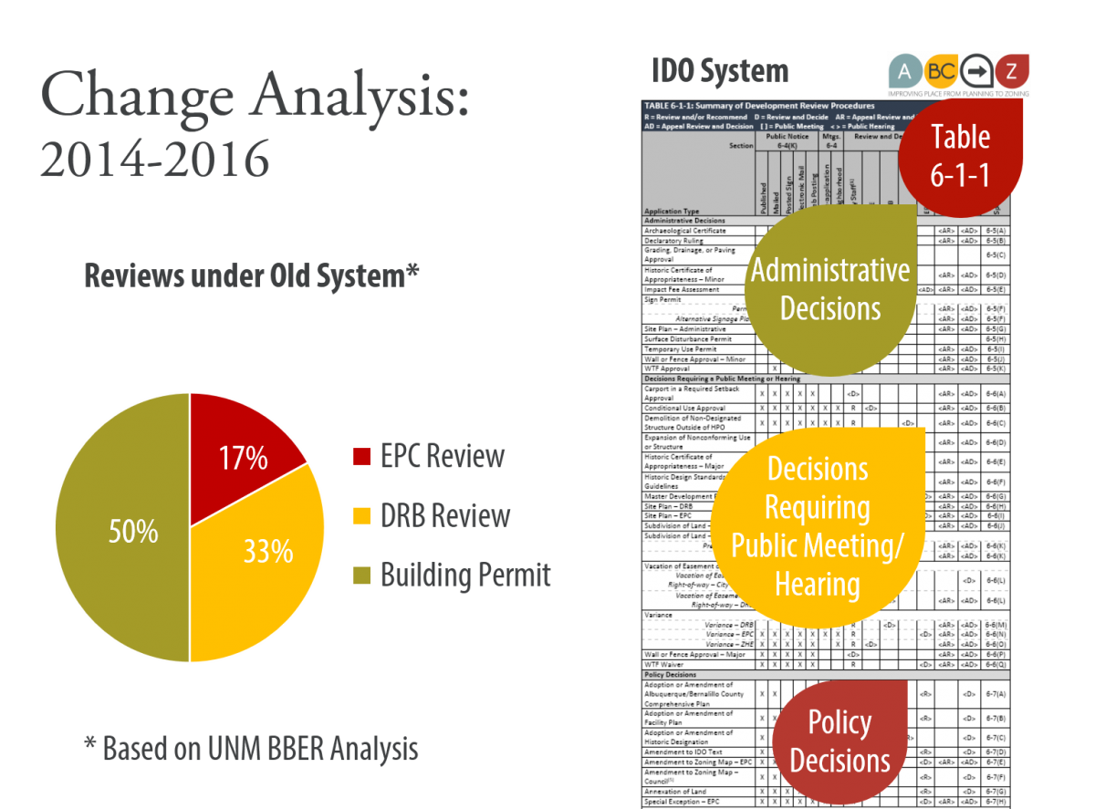
Under the IDO, the EPC remains a discretionary decision-making body, whose role is to review and recommend legislative changes and to review and decide on land use decisions based on consideration of policies as well as regulations.
However, the intent of the ABC-Z project was to strengthen development regulations citywide, in every zone, requiring a higher quality of development across the board and building in protections for neighborhoods.
Under the IDO, the EPC continues to play a critical role in long-range planning through the review and acceptance of the Community Planning Area (CPA) assessments as they are developed, which will recommend amendments to City policies in the ABC Comp Plan and regulations in the IDO.
- The ongoing cycle of proactive long-range planning through the Community Planning Assessment process is designed to culminate in adopting recommended policy amendments in the 5-year update to the ABC Comprehensive Plan.
- The biennial update of the IDO is designed to include adopting regulatory amendments recommended by the CPA assessments accepted in the previous year.
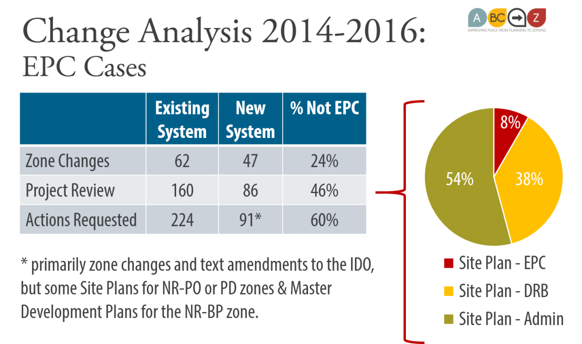
Staff looked at EPC agendas for three years to compare how the same projects from 2014-2016 might be reviewed/decided under the IDO. The spreadsheets are available below.
- Of the 62 zone map amendment requests that went to EPC, 47 (76%) would still require a zone change and would be reviewed by EPC.
- Of the 158 projects that came to EPC for review, 86 (54%) would likely still require EPC review under the IDO.
- Of the 226 requested actions (related to the 158 projects) that came to EPC for review, 91 (40%) would still require EPC review, primarily zone map amendments and text amendments to the IDO, but some site plans for NR-PO or PD zones and master development plans for the NR-BP zone.
Based on these expected shifts, the following pie chart shows the expected review/decision responsibilities for the same cases under the IDO.
See also:
Adopted Sector Development Plans and Area Plans were rescinded when City Council adopted Resolution 17-213 (R-17-213) in November 2017. These plans are now included as historical documents in Appendix D in the ABC Comprehensive Plan and available on the Planning Department webpage.
- Their policies have been incorporated in the ABC Comprehensive Plan (see Policy Matrix).
- Their regulations have been carried over into the Integrated Development Ordinance (IDO). (See Table I and II and the IDO Interactive Map).
Background
Over the last 40 years, the City adopted 4 Rank 2 Area Plans (policy only) and 60+ adopted Rank 3 documents (approximately 40 with policies only and approximately 45 with policies and zoning regulations). Most were Sector Development Plans (plans for small areas) and some were Corridor Plans. A few were Arroyo Corridor Plans and Design Overlay Zones. While each document had great information, taken together, this vast stack of plans made it very difficult to understand (without doing a lot of research) about what you could do on any particular property in Albuquerque.
On one side of the coin, the careful tailoring of regulations in these documents provided important protections for special places and neighborhoods.
On the other side of the coin, each one-off solution in a separate document created a crack for enforcement to fall into, not to mention differences in interpretation of different language and conflicts in overlapping plans.
While the City had every intent to update each of these plans every 10 years, the majority were much older than that. The City did not have the funding or the staffing to update them all. Some plans were very new or were updated multiple times. Some areas didn't have a plan. Some areas had very old plans that did not benefit from the latest zoning tools and protections for special places and neighborhoods.
- See a poster-sized map of the Rank 3 Plans & Overlay Zones
- See maps of Rank 3 Plans and Community Planning Areas by Council Districts
Each adopted Sector Plan regulation and SU-1 zone (of which there were hundreds in the City) was a symptom that the City's zoning code was too old to provide the combination of uses that the market wanted and the protections that neighborhoods and special places needed.
The ABC-Z project was intended to improve the zoning system to provide the uses we need and the protections we want, all in two documents that make it clear and predictable as to what development is desired and what is required.
Improving the Planning & Zoning System
ABC-Z shifted from the reactive, inequitable planning system of the past to an ongoing, proactive planning framework for the future. The City's Long-range Planning staff will work with each of the City's 12 Community Planning Areas (CPA) in sequence for six years.
- Recommendations for changes to regulations in the IDO will be used to update the Integrated Development Ordinance on a biennial basis.
- Every 5th year, all the data analysis and policy recommendations from all 12 CPA Assessments will be used to update the ABC Comprehensive Plan.
- Learn more about the Community Planning Area assessment process
Analysis of Adopted Sector Development Plans
The project team reviewed all the Rank 3 documents, many (but not all!) of which had some combination of policies, regulations, and other narrative content.
POLICIES
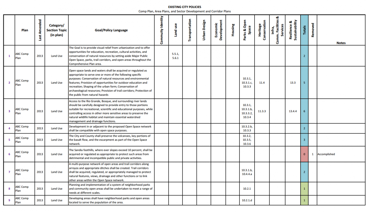
Policies from adopted plans were sorted into the relevant chapters of the Comprehensive Plan - the City's main policy document for land use and development. You can review that work via this Policy Matrix - a spreadsheet organized alphabetically by adopted plan that shows each policy as adopted and the policy number in the updated ABC Comprehensive Plan where the same intent appears. Adopted Rank 3 Sector Development Plans are included as Appendix D in the ABC Comprehensive Plan and posted for reference as historic documents here.
- Policy Matrix + Footnoted Comprehensive Plan
- Adopted Rank 2 Area Plans & Rank 3 Sector Development Plans
REGULATIONS
Regulations from adopted plans were sorted and incorporated into the Integrated Development Ordinance. Summaries were prepared for each of the adopted documents and are listed below.
- See also:
- OTHER CONTENT: The narratives, objectives, capital projects, and other content from these plans (which are neither policy nor regulation) are preserved in the ABC Comprehensive Plan Appendix D. This information is being used for Assessments of each Community Planning Area, which began after the end of the ABC-Z project.
- Read more:
- CPA Assessment process
- ABC Comp Plan
- Chapter 4: Community Identity
- Chapter 14: Implementation
- Appendix C: City Area & Sector Development Plan History
- Appendix E: How the City Will Plan With Communities In the Future
- Read more:
Frequently Asked Questions
- What happened to Sector Development Plans?
- What happened to zoning from Sector Development Plans (e.g. SU-2 zones)?
Handouts
- How the Sector Plans were impacted by ABC-Z
- Sector Plan provisions that have been extended citywide
- How to compare pre-IDO zoning to IDO zoning
- Conversion Table of SU-2 zoning from Sector Plans to IDO zones
PLAN SUMMARIES
For summaries of how the ABC-Z process deals with each adopted plan, see below (listed in alphabetical order):
- Academy/Eubank/Tramway Sector Development Plan
- Alameda Blvd. Design Overlay Zone
- Barelas Sector Development Plan
- Central Avenue Neon Design Overlay Zone
- Coors Corridor Plan
- Downtown Neighborhood Area Sector Development Plan
- Downtown 2025 Sector Development Plan & Metropolitan Redevelopment Plan
- East Atrisco Sector Development Plan
- East Gateway Sector Development Plan
- East Downtown Regulatory Plan
- El Rancho Atrisco Sector Development Plan - Phase III
- High Desert Sector Development Plan
- Huning Castle & Raynolds Addition Sector Development Plan
- Huning Highland Sector Development Plan
- La Cuesta Sector Development Plan
- La Cueva Sector Development Plan
- La Mesa Sector Development Plan
- Lava Shadows Sector Development Plan
- Los Candelarias Village Center & Metropolitan Redevelopment Plan
- Los Duranes Sector Development Plan
- Los Griegos Sector Development Plan
- Martineztown/Santa Barbara Sector Development Plan
- McClellan Park Sector Development Plan & Metropolitan Redevelopment Plan
- Mesa del Sol Sector Development Plan
- Nob Hill Highland Sector Development Plan
- Nor Este Sector Development Plan
- North Fourth Sector Development Plan & Metropolitan Redevelopment Plan
- North I-25 Sector Development Plan
- North Valley Area Plan (Rank 2)
- Northwest Mesa Escarpment Plan
- Old Town Sector Development Plan
- Quintessence Sector Development Plan
- Rio Bravo Sector Development Plan
- Rio Grande Blvd. Corridor Plan
- Riverview Sector Development Plan
- Sandia Foothills Area Plan (Rank 2)
- Sawmill/Wells Park Sector Development Plan
- Seven Bar Ranch Sector Development Plan
- South Broadway Sector Development Plan & Metropolitan Redevelopment Plan
- South Martineztown Sector Development Plan
- South Yale Sector Development Plan
- Sunport Blvd. Design Overlay Zone
- Southwest Area Plan (Rank 2)
- St. Joseph Hospital / Civic Auditorium Area Sector Development Plan & Metropolitan Redevelopment Plan
- Tower/Unser Sector Development Plan
- Trumbull Sector Development Plan
- University Neighborhoods Area Sector Development Plan
- University of Albuquerque Sector Development Plan
- Unser Blvd. Design Overlay Zone
- Uptown Sector Development Plan
- Vineyard Sector Development Plan
- Volcano Cliffs Sector Development Plan
- Volcano Heights Sector Development Plan
- Volcano Trails Sector Development Plan
- West Mesa Sector Development Plan
- West Route 66 Sector Development Plan
- Westland Sector Development Plan
- Window G Sector Development Plan
- West Side Strategic Plan (Rank 2)
Resources
- SU-2 Conversion Table (zones established by Sector Plans)
- SU-1 & RD Conversion Table (site-specific zones & RD conversions)
- IDO Effective Draft - Footnote Version (with Sector Development Plan references)
- Updating the Comp Plan
- Framework Plans
- Metropolitan Redevelopment Plans
- FAQ: What happened to the City's Arroyo Corridor Plans?
- Neighborhood Association Recognition Ordinance (a.k.a "O-92") - See ONC for update process
- Application Fees
- Impact Fees
- District Court processes (i.e. appeals beyond Council or enforcement actions)